For
more information on GIS services, project design, or quotes please
contact:
Steve
Boyle, Principal and Senior Biologist
BIO-Logic,
Inc. has the advanced computing power and
experience for all your data creation, analysis, mapping, and
presentation needs. We digitally enhance photos, georeference scanned
images, correct projection issues, digitize overlays, and provide maps
and data on paper, disk, and web-pubish.
GIS
(Geographic Information Systems)
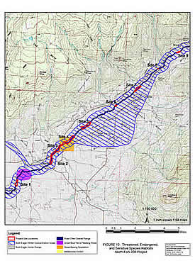
alt="Threatened Endangered Species T&E TES">
BIO-Logic,
Inc. maintains a full-service GIS shop that provides
GIS support to biology, geology, and wetlands projects and also
provides data conversion, data acquisition, projection and projection
conversion, vectorizing (digitizing), advanced geospatial analysis
using vector and raster analysis tools, model building, QAQC of
produced and acquired data and GIS outputs, and GIS training.
We maintain an extensive
digital library that includes collarless and collared topographic maps
(DRGs) for the state of Colorado, the most recent 1-meter or better
black and white or color aerial imagery produced from orthorectified
aerial photographs (DOQQs), and vector wildlife activity areas and
habitat areas, geologic data, soils data, climate data, landuse and
landcover grids, vegetation data, wetlands and floodplain data, and
current mining data which allow us to perform GIS tasks for regulatory
reports, wetland delineations, and biological and geological
assessments.
We maintain excellent working
relationships with federal, state, and local regulatory agencies and
surveyors which allows us to acquire current spatial coverages quickly
and efficiently. We also provide on-site training and off-site
technical support to GIS technicians at private, non-profit, and
government offices.
All GIS projects are designed
around case-specific project purpose, resolution, schedule, budget,
projection, data input and output format requirements and availability,
and metadata requirements. We utilize ESRI, Lizardtech, CAD, and other
software to provide high-quality geospatial products in many desired
formats.
Our GIS clients and projects
include:
Town of Ridgway-- GIS project support and
training Colorado Division of Wildlife--
Gunnison Sage-grouse Conservation Agreement Documentation, property and
habitat mapping Colorado Division of Wildlife--
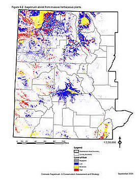
Colorado Sagebrush: A Conservation
Assessment and Strategy, ecological modeling and risk
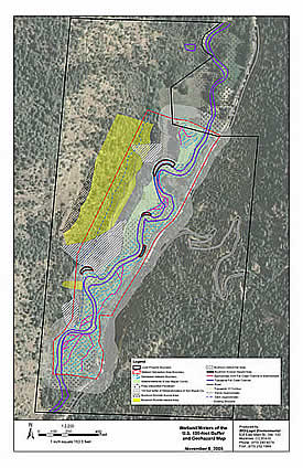
analysis U.S. Army Corps of Engineers--
North Fork Gunnison River Restoration Project, riparian and aquatic
habitat mapping and analysis Bureau of land
Management, Grand Junction Field Office-- Gunnison Sage-grouse Habitat
Mapping, resource mapping and analysis Tri-State Generation & Transmission
Association-- Transmission Line Projects, biological and wetland
resource mapping Bureau of Land Management,
Colorado State Office--Programmatic BA/BE for Resource Management
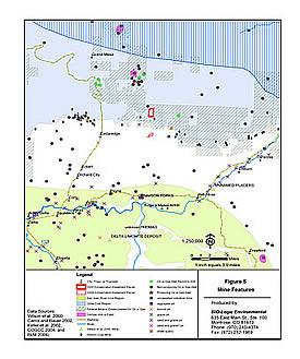
Plans, biological resource mapping and risk analysis The Nature Conservancy--Tamarisk Survey, Lower
San Miguel River, resource mapping Uncompahgre
National Forest-- Burn Canyon Weed Inventory, resource mapping Wildlife Management Consultants &
Associates-- GIS mapping, Routt County Colorado Land and Water Specialists--GIS mapping,
Gunnison County projects Ingo Ranch--GIS
mapping, Ouray County Trust for Land
Restoration-- GIS mapping, Ouray County
Links to useful websites can
be found here. >>Links
 alt="Threatened Endangered Species T&E TES">